
It’s a long way from Mobile, Alabama to Pickwick Lake on the Mississippi/Tennessee border. It would feel long even if there were not floating trees to dodge and massive barges to be navigated around, but add to the mix, the numerous locks to traverse, the very few anchorages or marinas to stop at, and the season’s first named storm brewing, and the distance seems even longer. In this situation, ten-hour days become the norm, and time off from traveling feels like a reward well earned.
 This smiling guy swam by while we were still in Mobile, AL
 Leaving Mobile, we saw this ocean exploration vessel.
 Mobile, AL skyline
 Barges are king on the rivers.
 This little guy was along for the ride.
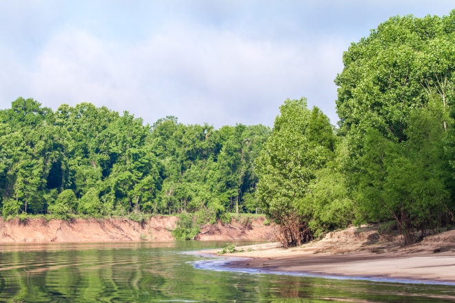 I wondered where all the logs and debris could come from, and then it became apparent. One side of the river has calm beaches but the other side has banks that are badly eroding, and trees fall from those banks and float down the waterway. Here is the beach side.
 And here is a side with severe erosion.
 This cute little dragonfly rode with me for quite a long while!
 More beach vs. erosion on the Tombigbee River.

 The first of several locks we traversed. We were alone in every one except this and one other.
 A beautiful morning scene.
 These rocks almost seem to be painted.
 Reflections on the river.
 A tiny hut for fishermen?
 White pelicans at the base of the dam.
 Next to the next lock were these pretty dramatic falls coming over the dam. Apparently they are good for fishing.
We left Mobile on May 16thafter accomplishing everything we hoped for at Dog River Marina. It felt so good to be on our way again, and from reports we had heard, the Tombigbee River was in much better condition than it had been over the previous weeks. It was good we waited because there were still countless huge logs and trees floating south as we moved north, and those that weren’t floating were sunken with little showing above the waterline. For John, especially, putting in long days was truly exhausting. Rest did not come easily, however, as many of the anchorages we expected to suit us well were too small or too shallow for us to squeeze into. We managed to find small anchorages two nights, but one night was spent right on the river after asking a tugboat captain to warn others of our presence. Anchoring on the river itself is frightening as it is narrow and its path twists, often in 180-degree turns; there is always the possibility of a tug with barges three wide and three long, for a total dimension of 100 feet by 600 feet, passing by and needing to make wide swings to get around the turn. Cell service was almost non-existent for the 216 miles in this stretch; there were no houses along the way, and not a single marina, with the exception of Bobby’s Fish Camp that looked pretty weak and a bit sketchy to us. There were, however, trees, lots of trees, but not a single palm tree. And once again, we were back to locks that lifted us to higher water.
 Along the Demopolis River Walk
 Scenes from the town of Demopolis, AL


May 19th brought us to the Kingfisher Bay Marina in Demopolis, Alabama. We were happy to stop and relax, and I was thrilled to find a very nice swimming pool. The marina also offered the use of a courtesy car, which is always a pleasant convenience. We didn’t need any groceries or supplies while we were there, but we did take the car to look around town one day and then I took it another day myself to take a few pictures and to check out the fresh produce market. While we were in Demopolis we started seeing signs of a tropical storm forming in the southern part of the Gulf of Mexico. As always, weather determines everything we do, and, although we had planned to take our time heading north, we realized that we needed to leave our safe marina and move quickly. The heavy rains that Alberto was promising would once again add to the flooding rivers and floating debris, so we chose to fast track our way to Pickwick Lake in Tennessee, 240 miles farther north from Demopolis, along the Tenn-Tom Waterway.
 Our first sight of the white cliffs along the way.
 Watching a flock of white pelicans get into formation.


 How would you like to encounter these two tugs with their barges when going around a curve?
 Signage on most of the barges we pass.
 And on to more cliffs, the White Cliffs of Epes. These cliffs are part of a formation called the the Selmas Chalk Formation and were deposited about the same time as the White Cliffs of Dover.
  More beautifully colored rocks.
 Sumter Recreation Area anchorage.
 This large lock lifts boats 85 feet.
 Birds often hang out in locks as they seem to be great fishing grounds. I watched an osprey catch two fish while we rose. But here, on the bottom of the right, in the horizontal bars, a great blue heron sat waiting for his chance to fish. Can you spot him?
 Now can you see him flying as the water interrupted his stay? He did this over and over during the time water was entering the lock.
 For those interested, these locks are slightly different than those we have used before as most locks give us a way to tie up bow and stern. Here, however, just one tie is possible. The line handler (John) wraps a line around this post that rises with the incoming water.
 The walls are rough and dirty and have completely destroyed our fender covers. I will replace them when we finish with the rivers!
 Up 85 feet and onto the entrance of the Tennessee River!
 And the friendly great blue heron makes his last stop before starting on the descent.
We left Demopolis on the 24thand once again, we traveled long nine to eleven-hour days. Thankfully, the rivers were much more clear of debris, but there were still plenty of barges and lots of locks to deal with. Our first night took us to Sumter Recreation Area, which really just consisted of a boat ramp and a tiny but beautiful anchorage. Then, on May 25th, we arrived at a marina in Columbus, Mississippi. We would have like to have stayed there, but, with Alberto churning in the Gulf of Mexico and making us hurry along, that town will be added to “On Our Way Back” list. After yet another long day we arrived at Midway Marina on the 26th, and finally at Grand Harbor Marina on Pickwick Lake on the 27th. Grand Harbor is a lovely marina with a great pool, courtesy cars, and nearby attractions. We are happy to be here because it is from here that we will rent a car and drive to Jacksonville, FL next week for Madison’s recital and for a visit with Kelly and her whole family.
Our plans have changed now, for the summer. While our original goal was to head up the Tennessee River to Kentucky, the reviews of the River from Pickwick Lake to Knoxville, Tennessee are just too glowing to pass up. There seem to be lots of towns to stop in and calm and protected anchorages along the way. We look forward to a leisurely trip with beautiful sights to see as we make our way towards the Smokey Mountains. Today we sit in heavy rain, but Alberto seems to have lost some of his steam; it’s peaceful on AfterMath now, although we have just gotten flood alerts on our phones. I guess the good part of being on a boat is that we can just float away if need be. In the meantime, we will stay comfortable and cozy in our house on the water. And to all of you, stay safe this summer and make sure you take some time to enjoy every single day.
